My GNSS send RTK position, it’s a rover who received correction by 4G modem by connection to NTRIP Caster or by radio modem when corrections are transmet by my GNSS Base.
Setup:
GPS_TYPE: 5
GPS_SBP_LOGMASK: -256 (I don’t understand this option and I don’t test -1 or 0)
GPS_GNSS_MODE: 0
GPS_RATE_MS: 200
SERIAL3_PROTOCOL: 5
SERIAL3_BAUD: 38
My GNSS output data by DB9 RS232 femelle , I build a cable with DB9 male to GPS1 connector, Pin2 DB9 to Pin2 GPS1, Pin3 DB9 to Pin3 GPS1 and Pin5 DB9 to Pin8 GPS1. I test another cable, Pin2 DB9 to Pin3 GPS1, Pin3 DB9 to Pin2 GPS1 and Pin5 DB9 to Pin8 GPS1.
Has anyone made this kind of connection before? I can find no information about it!
Is there a documentation that details the frames and parameters for using the NMEA data of a GNSS RTK for navigation(Boats) and the log of the positions of a measurement (sonar in my case).
Thanks a lot for the information, I basically thought that just put RX on TX and TX on RX. I’ll order a converter and go back on the operation.
A simple SERIAL to USB converter don’t do that?
Sorry for my English, I’m French.
Hello,
I come back for explain my solution.
I have order a low cost converter by Amazon, but it’s not work after some test.
Finaly I buy a Sparfun converter PRT-08780, and it’s OK I can use my Survey GNSS!
Thanks
Hello,
For the moment I can’t doing test in France, my project is a boat.
On my boat I have a rover GNSS who receive correction by his radio from a base install on know point.
Rover send NMEA GGA, RMC and VTG at 5Hz,115200 baud to Pixhawk. I don’t know if RMC and VTG are use by Pixhawk, no docs for explain what NMEA message are importante for navigation.
Without navigation test I have juste change EK2_ALT_SOURCE at 2 for use altitude from GNSS and no barometer, it’s important for my project to have ellipsoid height for referencing my bathymetrie on french system.
After first test, if I change parameter I come back here.
For me it’s a survey GNSS, T300+ by Comnav technology.
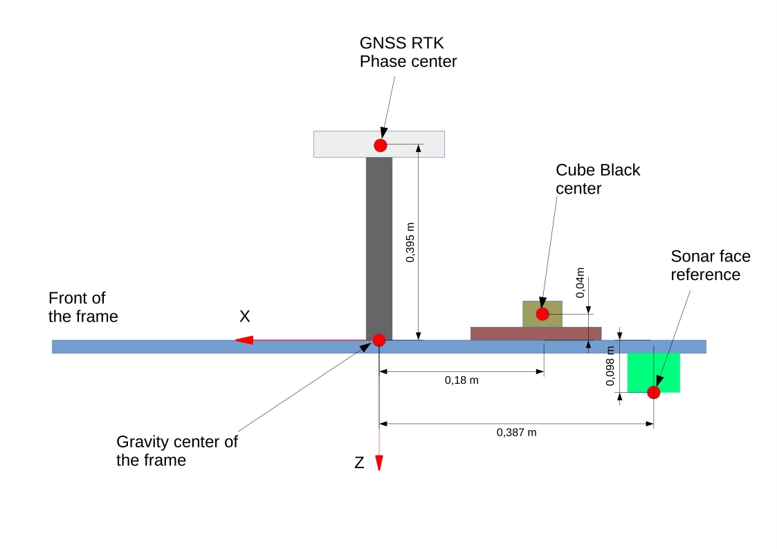
Now, with NMEA it’s OK but I have problem for setup position Offset for my GNSS, IMU and Sonar.
Can you help me with this draw?
I am connecting a Novatel OEM7 729 to the orange cube. You mentioned nova messages above. do you know what the configuration may be on the Novatel side to send these message? bestpos? PSRvel?