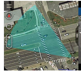
I want this type of Gimbal field of view in the Map… I am using Herelink and accessing video via Ethernet port. please help me out, How I can achieve this.
Thanks

I want this type of Gimbal field of view in the Map… I am using Herelink and accessing video via Ethernet port. please help me out, How I can achieve this.
Thanks
Can you describe this more? Where is this screenshot taken from?
Hello philip,
The screenshot shared is random mapping picture.
What I need…??
Like in Mission Planner and QGC, we are able to see the head of drone in the map, which is basically indicates the drone location and heading direction. I want that the gimbal heading direction & field of view also accessible along with drone direction/location.
So, How I can get the solution for this, what the changes I have to make.